


In this guide (9 sections)
- At a glance
- The Passage du Gois: the history of a causeway
- Crossing the Gois at low tide
- Crossing times: where to find them
- Safety: the refuge beacons on the Gois
- Shore fishing around the Gois
- The Foulées du Gois: a race against the sea
- Getting there from Saint-Hilaire-de-Riez
- Your questions about the Passage du Gois
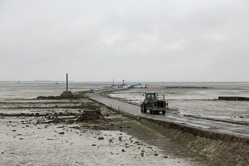
The Passage du Gois to Noirmoutier is a tidal causeway of around 4.2 km, covered by the sea twice a day. It links Beauvoir-sur-Mer to the island of Noirmoutier, in the Bay of Bourgneuf. The road is only passable around low tide. When the tidal coefficient is above 70, the tourist office advises crossing up to 1 hour 30 minutes before and after low tide. Low tide times change every day. The tourist office publishes the L’Herbaudière tide times online. Signs at both ends display the tide times. Along the way, nine refuge beacons give shelter to anyone caught out by the rising water. This Vendée site is about 32 km from Au Bois des Biches campsite in Saint-Hilaire-de-Riez. The journey takes around 35 minutes, via Saint-Jean-de-Monts.
Key points to remember
| Item | Details |
|---|---|
| Length | Around 4.2 km of paved causeway |
| Crossing window | Up to 1 hour 30 minutes either side of low tide, when the tidal coefficient is above 70 |
| Low tide times | Different every day, published by the tourist office |
| Shelters | Nine refuges along the causeway |
| Protection | Protected site, classified by decree of 2 November 2017 |
| Shellfish | Clams, cockles and oysters, with regulated sizes and quantities |
| Annual event | Next edition announced for Saturday 26 June 2027 |
| From the campsite | About 32 km, 35 minutes to the start of the causeway |
Passage du Gois: the story of a causeway
The name is thought to come from the Low Latin “guazzare”, which became “goiser” in Vendée dialect. The word means “to walk with wet feet”. The town of Barbâtre dates the name back to around 1577. A map from 1701 shows this ford between the island and the mainland for the first time. According to the tourist office, Auguste Gauvrit opened the crossing in 1766. Simple stakes marked the route from 1780, at the end of the 18th century.
In the 19th century, around 1840, a regular horse-drawn carriage service linked the two shores. The stones of the causeway were laid from 1872.
In the 20th century, paving began in 1935 and the work was completed in 1939. The former national road 148 is now the D948.
The Gois was the only road link to the island until the Noirmoutier bridge opened in 1971. The site was added to the inventory of sites of the Vendée département in July 1942. A decree of 2 November 2017 protects the wider area it forms with the Île de la Crosnière and the Sébastopol polder.
The tourist office regards it as a site of national and heritage interest. Its page also describes it as “a submersible road unlike any other in the world”.
This unusual crossing hosted the Tour de France in 1993, a first.

Crossing the Gois at low tide
The causeway is uncovered twice a day as the tide goes out. Cars, cyclists and pedestrians can then use it. At high tide, the depth of water covering the causeway depends on the tide coefficient. According to the island’s municipality, it ranges from 1.30 m to 4 metres. The tourist office sets out the crossing window, relative to the time of low tide, as follows:
| Coefficient | Crossing window given by the tourist office |
|---|---|
| Over 70 | Up to 1 hour 30 before and 1 hour 30 after |
| Between 50 and 70 | From 30 minutes to 1 hour before and after |
| Below 50 | Aim for a time close to low tide |
The weather makes a difference too. In strong winds or storms, the Gois closes sooner, according to the same source. The island’s municipality also limits the 1h30 rule to fine weather and high tidal coefficients.
Crossing times: where to find them
There is no fixed time slot, as the tide shifts from one day to the next. This content therefore gives no crossing times. The reference to use is the Tides and weather page from the Noirmoutier tourist office. The times there are based on SHOM predictions for the port of L’Herbaudière. The page states that this reproduction has not been verified by SHOM. On site, signs display these times on both the island side and the mainland side.
Satnavs sometimes suggest the Gois without taking the sea or the weather into account.
The tourist office therefore advises checking the tide time before following the route. The bridge, further south at Fromentine, reaches the island at any hour.

Good to know
According to the island’s town hall, tide notices have been displayed near the crossing since 1830. Despite these signs, incidents still happen every year.
Safety: the refuge beacons on the Gois
Nine refuges line the causeway. They shelter anyone caught out by the rising tide. The commune lists six mâts de perroquet (topgallant masts) and three other shelters fitted with cages. Marker posts, set every hundred metres, also show the route. Fog is another danger. According to the tourist office, it can make shore foragers lose all sense of direction. They can then be trapped by the incoming tide.
Shore fishing around the Gois
At low tide, the area around the Gois attracts many enthusiasts, especially when the tides are big. The area is known for its wild clams, cockles and oysters. The tourist office also mentions the area stretching as far as the oyster beds. This leisure activity is subject to minimum sizes and limits per person. The tourist office gives the following guidelines, which may change:
| Shellfish | Minimum size | Quantity per person |
|---|---|---|
| Manila clam | 3.5 cm | 3 kg |
| European clam | 4 cm | 3 kg |
| Cockle | 2.7 cm | 4 kg |
| Pacific oyster | 5 cm | 5 dozen, up to a maximum of 5 kg |
Only the three-pronged hand rake and the clam knife are permitted. Selling your catch is still forbidden. The Regional Health Agency (Agence régionale de santé) keeps an up-to-date list of the sites closed to shellfish gathering. Our guide to rockpooling and shellfish gathering on the Vendée foreshore introduces other spots along the coast.
Good to know
The site is part of the Natura 2000 zone “Marais breton, baie de Bourgneuf, île de Noirmoutier et forêt de Monts”. The report that preceded this protection status mentions that gathering activities may continue.
The Foulées du Gois: a race against the sea
Every year, usually in June, a race turns the causeway into a racetrack. The idea was born in 1986: to run against the rising tide. The Passage du Gois, described as legendary by Vendée Tourisme, serves as the course. Volunteers from the association Les Amis du Gois organise the event. The 38th edition took place on Saturday 20 June 2026. The programme includes races for children and young people, popular races, adapted sport and the elite race against the rising tide. Since 2022, invited athletes have also run at low tide. The organisers have announced the next edition for Saturday 26 June 2027. For runners, the Noirmoutier half marathon adds another date to the year’s calendar.
Getting there from Saint-Hilaire-de-Riez
From the campsite, allow around 32 km to reach the entrance to the causeway, which takes about 35 minutes. The route goes through Saint-Jean-de-Monts, then continues to Beauvoir-sur-Mer via the D51 and D22. The D948 then leads to the start of the Gois on the mainland side.
You can return via Fromentine, with no tide times to worry about. Further north, the salt marshes reveal the salt harvested by the salt workers of Noirmoutier.
For the 2027 season, the 4-star campsite near Noirmoutier offers mobile homes, lodges and chalets. Its pitches measure 120 to 150 m².
A tip from the campsite team
Crossing by the Gois on the way there and coming back by the 1971 bridge means you avoid any wait for the tide. The day’s low tide time is on the tourist office website.
Your questions about the Passage du Gois
How long before and after low tide can you cross?
Up to 1 hour 30 minutes, when the tidal coefficient is above 70. Between 50 and 70, the tourist office advises 30 minutes to 1 hour. Below 50, the advice is to cross closer to low tide. In strong winds, the Gois closes sooner.
Where can I find the Gois crossing times?
On the Tides and weather page of the tourist office website. It gives the low tide times and the safe margin for each tidal coefficient. Signs display the tide times at both ends of the causeway.
How many refuge beacons are there on the Gois?
Nine refuges line the causeway. Six are “mâts de perroquet” (pole refuges) and three have a cage, according to Barbâtre town hall.
How long is the Gois crossing?
About 4.2 km, according to the tourist office. Other official sources give similar figures, from 4.15 to 4.5 km.
When do the Foulées du Gois take place?
On Saturday 26 June 2027, according to the organisers. The 2026 edition, the 38th, was run on 20 June.
Who wrote this article?
Article written by the team at Camping Au Bois des Biches, a 4-star campsite in Saint-Hilaire-de-Riez, in the Vendée. Information checked on 26 October 2026 with the tourist office, local authorities and official bodies. Please check tide times on the day itself. Sources consulted:
- Office de tourisme de l’île de Noirmoutier (Noirmoutier Island Tourist Office), Le passage du Gois (ile-noirmoutier.com)
- Office de tourisme de l’île de Noirmoutier (Noirmoutier Island Tourist Office), Marées et météo (ile-noirmoutier.com)
- Office de tourisme de l’île de Noirmoutier (Noirmoutier Island Tourist Office), La pêche à pied (ile-noirmoutier.com)
- Commune de Barbâtre, Le site du Gois (barbatre.fr)
- Vendée Tourisme, Le passage du Gois (vendee-tourisme.com)
- Vendée Tourisme, Les Foulées du Gois (vendee-tourisme.com)
- Région Pays de la Loire, En Pays de la Loire, Passage du Gois (enpaysdelaloire.com)
- Ineris, AIDA, décret du 2 novembre 2017 portant classement du passage du Gois (decree of 2 November 2017 on the listing of the Passage du Gois) (aida.ineris.fr)
- CGEDD, rapport 010355-01 sur le classement du passage du Gois (report 010355-01 on the listing of the Passage du Gois) (igedd.developpement-durable.gouv.fr)
- ARS Pays de la Loire, Où pêcher à pied en Pays de la Loire (where to go shore fishing in the Pays de la Loire) (pays-de-la-loire.ars.sante.fr)
- Les Foulées du Gois, official website of the race (lesfouleesdugois.com)


